

Ouvre ce point d’intérêt dans l’application pour préparer ta prochaine sortie

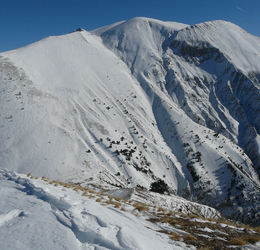
Montagne de Boules
France • 2391 m

Panorama
Vue">https://www.toporandosmontagne.com/04/prealpes-digne/denjuan/pano-pic-mal-ubac-annote.JPG">Vue du Pic de Mal Ubac par toporandosmontagne.com Vue">https://www.toporandosmontagne.com/04/prealpes-digne/montagne-coste-longue/pano-montagne-coste-longue-annote.JPG">Vue de Coste Longue par toporandosmontagne.com Vue">https://www.toporandosmontagne.com/04/prealpes-digne/sommet-paluet/pano-sommet-paluet-annote.JPG">Vue de la Crête de Paluet par toporandosmontagne.com Vue">https://www.toporandosmontagne.com/04/prealpes-digne/denjuan/pano-sommet-denjuan-annote.JPG">Vue du Sommet de Denjuan par toporandosmontagne.com Vue">https://www.toporandosmontagne.com/04/prealpes-digne/mourre-simance/pano-mourre-simance-annote.JPG">Vue du Mourre de Simance par toporandosmontagne.com Vue">https://www.toporandosmontagne.com/04/prealpes-digne/estrop/pano-estrop-annote.JPG">Vue de la Tête de l’Estrop par toporandosmontagne.com Vue">https://www.toporandosmontagne.com/04/prealpes-digne/boules/pano-boules-vierge.JPG">Vue de la Montagne de Boules par toporandosmontagne.com Vue">https://www.toporandosmontagne.com/04/prealpes-digne/boules/pano-carton-vierge.JPG">Vue de la Montagne du Carton par toporandosmontagne.com Vue">https://maps.app.goo.gl/A161pufmSbDmT6Mu7">Vue au dessus de ND de Lauzière par Drône des Cîmes


Télécharge l’appli Whympr pour voir ce POI en 3D.
- Recherche d'itinéraires (100 000)
- Retours communautaire
- Prévision météo
- Bulletin d’avalanche
- Carnet de course
- Création de traces
- Carte topographique (dont IGN)