

Open this route in the app to prepare your next outing.

Details
Approach
From the top of the Index chairlift, follow the path which goes to the Gliere ridge then climb up the scree slope to until you get a view of the W face of the Index. The route starts at a little promontory to the right looking up. (A red stake.)
Route
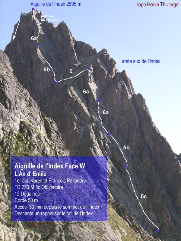
L1 : 5c+ Thin moves on a slab. 40m L2 : 5b Slab 30m L3 : 6a Nice pitch, with a slightly strenuous section, (some of the holds seem fragile) 40m L4 : 6a A slabby start then a nice corner 40m L5 : A linking pitch on easy ground to the continuation of the route on the face down to the left. L6 : 5b Slightly strenuous start then a beautiful slab 40m L7 : 6a A thin start then back onto the spur on the right. 40m
Descent
At the top of the climb you join the classic route of the Index. One abseil brings you to the col from where you can walk/scramble down the gully. There is an abseil line in the gully in case of snow.

The text and images in this page are available
under a Creative Commons CC-by-sa licence.

Download the Whympr App to view this route in 3D.
- Route search (100 000)
- Community returns
- Weather forecast
- Avalanche bulletin
- Race book
- Creation of tracks
- Topographic map (including IGN)