

Open this route in the app to prepare your next outing.

Details
Ascent: The route was opened by E. Navarro and A. Rabada from 15 to 17 August 1961.
From the Ordesa parking lot, follow the walkway which leads to the Cotatuero waterfall. After passing a bivouac-shelter then a series of bends, a junction on the left goes towards Carriata. Follow it. From there the trail along the east face of the Gallinero. The route begins at the perpendicular part of the spur to the right of a clear square roof. From the parking lot to the start takes 1h15.
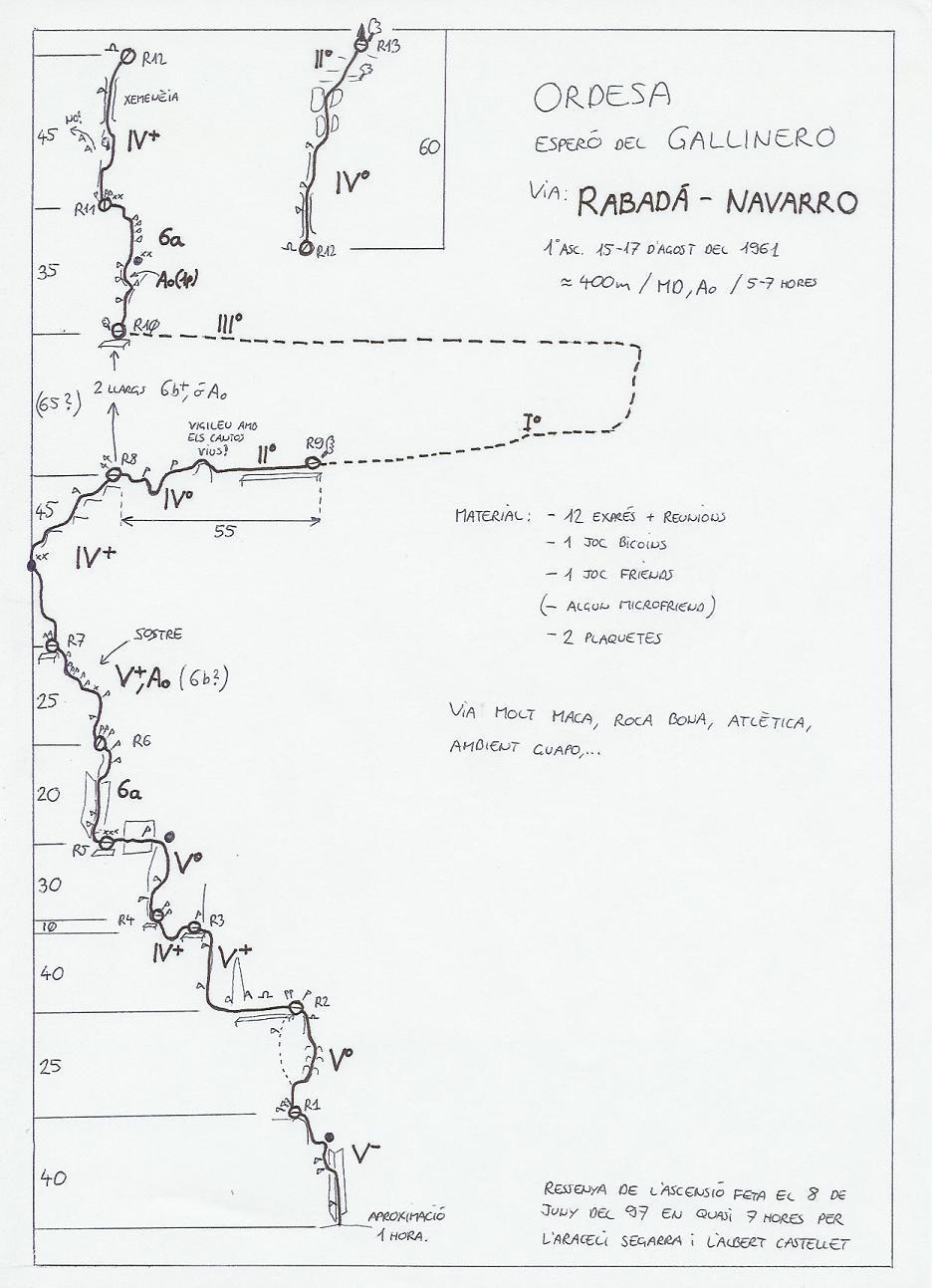
Climb a dihedral about forty metres high (IV +, UK-5a /US-5.8). Via a flake structure, surmount a spur on the left and mantleshelf on a cornice (IV +). Scale a steep wall then a series of dihedrals to reach another cornice (UK-5a /US-5.8). Travel it towards the left (a step of UK-4a /US-5.5). Climb a succession of dihedrals which shift slightly to the left during two pitches (UK-4c /US-5.7, UK-5a /US-5.8). Pass a spur on the left and climb a bald dihedral (6a+); it leads under the large roof. A thin wall and bridging movements make it possible to avoid the roof via the left (6b +). Go up steep pitches and relay towards the right (IV +). A horizontal traverse to the right makes it possible to reach a hanging garden. Go up it and via a large hook on the right, reach a cornice where you can recross on the left to reach the edge of the upper part of the spur. The route then goes up the chimney system which borders the edge of the spur on the right. Go up it on four pitches (6a +, V +, UK-5a /US-5.8) to reach the summit cornice. It takes 7h form the start to the summit.
Bibliography: - R. Munsch, C. Ravier, R. Thivel, Passages Pyrénéens, Editions du Pin à Crochets
Descent: It is splendid. Follow the summit cornice towards the north then cut back to the east to meet the Cotatuero waterfall and, via steps on its right bank to rejoin the approach route. Time 1h30.
The low altitude of the Ordesa walls, often makes it possible to climb from May to October.
It is one of the more classic routes of Ordesa. Climbing on these walls is over a very adherent sandy limestone. Broken and stratified, it provides plenty of roofs, overhangs and dihedrals. With its athletic style, the climb is often free. The rare sequences of aid that you will find reinforce the exposed environment of the routes. Nuts and friends are great on all the walls of the massif and slings will be a valuable aid to avoid rope drag.
Beautiful rock climbing, exposed and unrelenting, masterpiece of the famous Aragonese rope party.
Access: From France you reach Spain via the pass of Pourtalet (Vallée d’Ossau) or via the Bielsa tunnel (Vallée d’Aure). The Vallée d’Arrazas is part of the Ordesa National Park, located on the southern slope of the Gavarnie limestone massif. After the village of Torla, a recent shuttle system leads to the parking lot (every 15 minutes in summer between 6:00 a.m. and 10:00 p.m.).
Accommodation: Torla is small Zermatt (less expensive and more likeable), so there are no lodging problems. All forms of bivouac or camping are prohibited at the bottom of the valley.

The text and images in this page are available
under a Creative Commons CC-by-sa licence.

Download the Whympr App to view this route in 3D.
- Route search (100 000)
- Community returns
- Weather forecast
- Avalanche bulletin
- Race book
- Creation of tracks
- Topographic map (including IGN)