

Open this route in the app to prepare your next outing.

Details
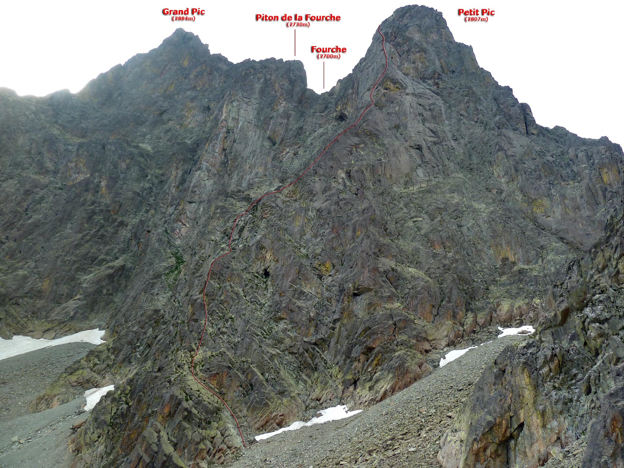
Ascent: J and P Ravier made the first climb of this spur on 24 June 1956 by traversing the middle part a chimney crack on the left-hand side of the pillar. The complete route described here is the work of J Bladé and Y Darcourt in 1967.
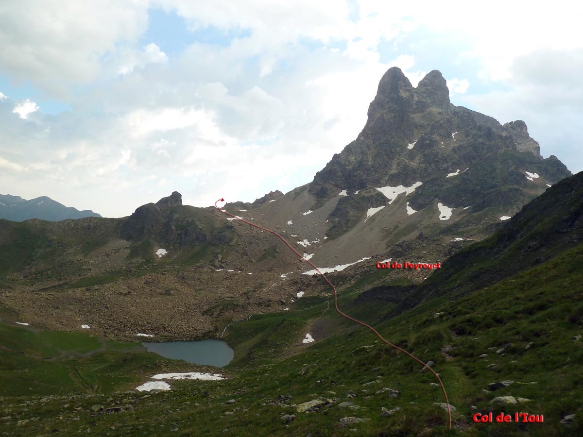
From Pombie refuge, cross the Peyreget pass and go around the West and North-west slopes of Petit Pic, start it are located at the lowest point of the walls before going up La Raillère of the cirque of the Embarradère. The approach takes 1h to 1h30.
Climb an inclined slab (UK-3a /US-5.3) then overcome a steeper pitch (UK-4a /US-5.5) as best as possible. It gives access to a system of ramps inclined towards the right; follow it (UK-3a /US-5.3). Return to the left and traverse an easy path to the left of the edge of the spur. You reach it at the foot of a very steep wall. Climb the cracked slab which dominates (UK-5a /US-5.8, V +) and leads to party ledges. Traverse 15 to 20 metres to the left and follow a system of vertically cracked slabs, in a circle arc towards the right (V +). A small suspended dihedral follows (V +). Continue more easily until reaching a vertical and featureless wall; cross it (6a + or A1). Higher, under overhangs, leave the edge of the spur to traverse to the left by following a ledge. At its end, climb a new open dihedral (UK-5a /US-5.8) and some slabs (IV +). It leads to the shoulder. From here there is a long traverse (UK-3a /US-5.3) which makes it possible to reach the Fourche. Some steps (II), a small vertical wall (UK-4a /US-5.5) and easy rocks lead to the summit of the Petit Pic. It takes 6h to climb.
Bibliography: - P. Dupouey Le Pic d’Ossau Denoël - R. Ollivier - Vallée d’Ossau - R. Munsch, C. Ravier, R. Thivel, Passages Pyrénéens, Editions du Pin à Crochets
Descent: The descent of the Petit Pic is made via the ridge of Peyreget. From the summit, climb down the easy rocks towards the south; you reach a large party ledge, equipped with a rappel bolt. Carry out a rappel of 40 metres in the chimney or downclimb (III + difficult). At its foot, go up a few metres to the right (orographic) and downclimb (I, II) other clear steps which lead to a less broken section of the ridge; and follow it. Downclimb a steep pitch via slabs in excellent rock on the Grande Raillère slope, then, when the horizontal crest is reached, descend a broad herbish corridor and easy Peyreget slope (it is dominated on the right by the ridge of the Flammes de Pierre) for approximately 200 metres. On the orographic left side cross a small notch marked by a cairn and a rusty bicycle wheel! It gives accesses to a system of cairned ledges (I, II) which leads to the walkway of the pass of Peyreget. The descent takes 1h30.

The text and images in this page are available
under a Creative Commons CC-by-sa licence.

Download the Whympr App to view this route in 3D.
- Route search (100 000)
- Community returns
- Weather forecast
- Avalanche bulletin
- Race book
- Creation of tracks
- Topographic map (including IGN)