

Open this route in the app to prepare your next outing.

Details
Ascent: It was on 8 August 1933 that H. Barrio and R. Bellocq carried out this climb in remarkable style since they placed no piton.
For the Oulettes de Gaube refuge, after the Pountas parking lot, follow the track of pont d’Espagne for 300 metres and head left to a waymarked track which leads to Lac de Gaube and then to the refuge. It takes 2h30. It is also possible to use Lac de Gaube chair lift but this solution does not save much time.
From Oulettes refuge, you reach the glacier of the Oulettes that is climbed on the right to the level of a characteristic green seam located below the bergschrund of the Gaube pass. Time 1h30.
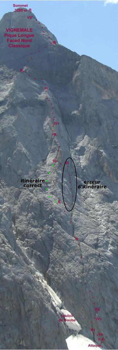
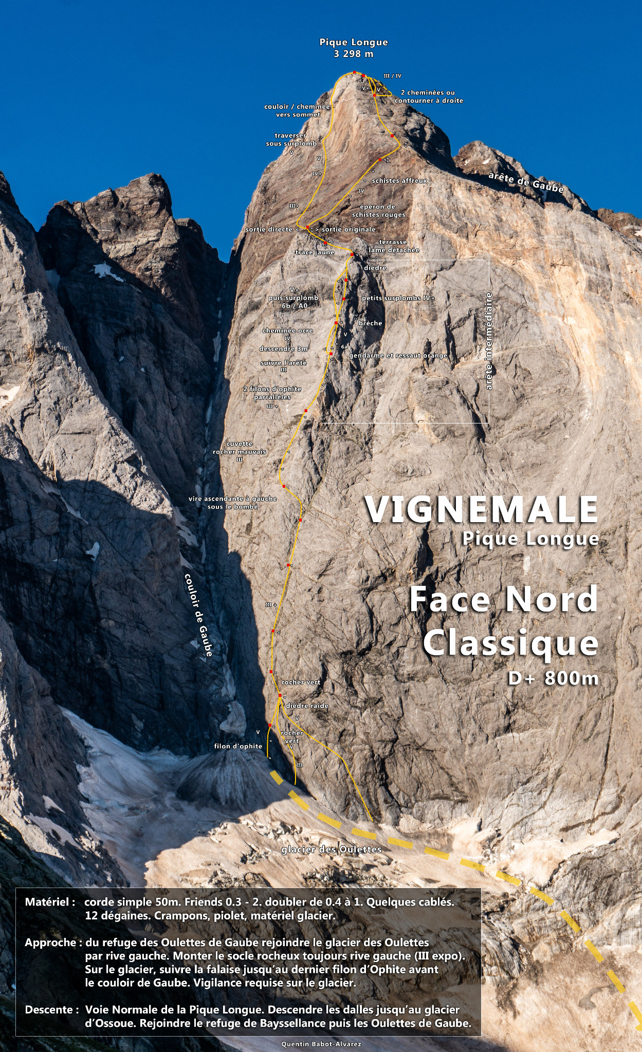
The classic start traverses the green seam referred to above that is gone up before going diagonally to the right towards a short chimney where you top out also on the right using a vein with side pulls that you follow until a good platform (all UK-5a /US-5.8, one to two pitches according to the height of the glacier). If this start proves unfeasible due to the bergschrund, a hundred meters down traverse a ledge system on the right which makes it possible to reach a steep dihedral leading on the left towards the above platform (UK-5a /US-5.8, two pitches). Traverse slightly to the left (UK-3c /US-5.5) to reach the ophite seam that follows it on two pitches (III +). The wall leans out. Continue as best you can for a hundred meters (UK-3a /US-5.3). You will then find a ledge which cuts the Arête Intermédiaire at its base, traverse it. Many rope parties climb too high in the direction of the Cheminée des Autrichiens and it is very difficult then to get to the Arête Intermédiaire. At the end of the ledge, cross a short steep pitch (III +) on the left which leads to a not very steep basin. Go up it via the green seam which reaches the Arête Intermédiaire in a small notch at the level of the first gendarme (UK-3a /US-5.3). Follow the edge of the ridge to the base of a vertical gendarme. Descend three meters on the left in order to go up a chimney in ochre rock which borders the ridge (IV -). Cross the following steep pitch via a short overhang (IV +) and continue more easily on the edge until a good party ledge. Traverse slightly to the right to reach a crack in grey and green rock that you go up on the right by surmounting a slight overhang (IV +). You arrive at a good party ledge with a detached pick. Return to the left and follow the edge of the ridge where the slope decreases (IV -then UK-3a /US-5.3). It finishes in a small dihedral that is crossed via its right woody. From the summit of the Arête Intermédiaire, safely traverse on the left towards the base of a spur well marked in the red schists of a summit part (III +). Here there are two solutions:
Original outing: climb completely to the right along this spur. You arrive under a steeper wall of about thirty meters that must be climbed as much as possible (UK-4a /US-5.5) in order to reach the diagonal ledge on the right which leads to Gaube ridge (UK-4a /US-5.5). Its final face is first climbed to the right and then via a slight hook to the left which leads under a steep wall. Traverse on the right via an overlapping ledge system which makes it possible to cross the western corner of the face and to emerge in easier corridors which lead to the summit (III +, steps of UK-4a /US-5.5). It takes 5-6h.
Direct outing: from the base of the red schist spur, turn completely to the left then continue as much as possible in the direction of the clear chimney resulting from the summit (III +). Go up it on three pitches intersected with small bulges (IV + and UK-5a /US-5.8). Traverse on the right for six meters at the level of an overhang (UK-5a /US-5.8) in order to reach a deep shoot which extends the chimney as far as the summit. It takes 7h. N.B.: this variant, a tone distinctly above the classic outing, was opened by F Gohier, J and P Ravier on 30 July 1967, at the time of the first ascent of the entire north face.
Bibliography: - P. de Bellefon, Les Pyrénées (100+belles), Denoël. - R. Munsch, C. Ravier, R. Thivel, Passages Pyrénéens, Editions du Pin à Crochets.
Descent: From the summit, go down to reach Ossoue glacier via steeply sloping rocks. Follow the glacier to the south-east by carrying out a hook on the right bank to avoid the crevasses. Under it, return on the left towards the southern foothills of Petit Vignemale where the main moraine is reached. Here there are two solutions: - follow the moraine until Bayssellance then climb to the Hourquette d’Ossoue and swing to the Oulettes slope. -it starts up on the left in chamois territory so as to cross directly the crest of Petit Vignemale at the level of the spot elevation 2731 m. You then emerge at the height of Hourquette d’Ossoue. This solution makes it possible to save about thirty minutes. From the summit to Bayssellance: it takes 1h30 From summit to Oulettes: it takes 2h30

The text and images in this page are available
under a Creative Commons CC-by-sa licence.

Download the Whympr App to view this route in 3D.
- Route search (100 000)
- Community returns
- Weather forecast
- Avalanche bulletin
- Race book
- Creation of tracks
- Topographic map (including IGN)