

Open this route in the app to prepare your next outing.


Details
Ascent
First ascent: Pierre Dalloz, Jacques Lagarde and Henry de Ségogne on 9 and 10 August 1925.
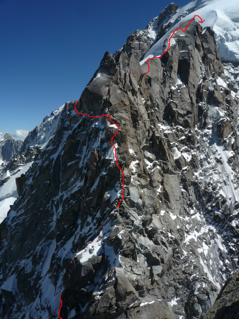
Grandiose, long and varied route in a superb setting (Versant Nant Blanc de la Verte, Couloir Nord des Dru…). The rock is good except in the traverses at the beginning.
From Col des Grands Montets you reach the shoulder NW of the ridge via the beginning of the Petite Verte route. (30 min to 1h00) Slightly descend the Nant Blanc slope, and traverse ascending towards the left to reach a transversal ledge system. Follow them and pass to the foot of gendarmes which form the ridge. Traverse a broad corridor and take the ledge on the other side (do not descend towards the downhill ledge). Continue the ledge until it disappears, then climb the chimneys which lead to a notch to the north of Pointe Farrar. Traverse via slabs in slightly ascending the Argentière side to reach the notch 3625m to the north of Tour Carrée. 2h00 to 3h00. Good bivouac site. Tour Carrée is climbed via a broad Argentière slope chimney (UK-4a /US-5.5, pitons) encumbered of large boulders and provides access to the ridge. Via tilted slabs then a crack you reach the summit of Carrée (3716m). Downclimb towards the following notch (3655m) via the Argentière slope (rappel of 20m at the end). From the notch cross the Argentière side, do not climb the broad and welcoming chimney on the right but continue until passing a small rock spur. Behind this spur climb a steep corridor via its right side (UK-4a /US-5.5) until a small party ledge. Climb the slab and traverse until the foot of a large slab cracked in its centre (UK-4a /US-5.5, IV +, unrelenting and exposed, splendid) then the summit of the Pointe Ségogne. Via 2 rappels of 25 and 30 m go down the pinnacle Argentière side to easily reach Col du Nant Blanc (4h00 to 6h30). Numerous bivouac sites. Go up the steep snow and ice slopes (50/60°), while remaining on the Argentière side to reach the summit of La Verte. (1h00 to 2h00)
Bibliography: - Guides Vallot volume 2. By F.Labande - Les 100 plus belles… By G.Rébuffat
Descent
Descent via the Whymper corridor Route to be undertaken only if the snow and ice conditions are appropriate. From the summit return to the Grande Rocheuse pass and enter the Whymper corridor (600m, 50° max). Rappels are fitted on the left side of the corridor, check that they hold before using them! In a last quarter of the descent pull more to the left (directions of the descent) to reach a secondary corridor, which leads to the bergschrund. There is a rappel fitted on the left. Once on the Talèfre glacier (very crevassed) you reach Couvercle refuge by taking the right bank of the glacier and traversing under Aiguille du Moine. The conditions and technical situation dictate the time span. From 55 min to 7h00 according to a study by F.Labande for the Vallot guide.
Descent via the Moine ridge This descent route should to be used when Whymper is too dry or in poor condition. The route, mixed and never difficult but long and unrelenting, starts directly under the summit in the direction of the Moine ridge, to the South. Do not take the more or less fitted out rappel line on Talèfre slope. Pass a pointed gendarme via the Talèfre slope, then stay on this slope, under the ridge until 3850 m. Descend a chimney corridor, 1 rappel on maillon, then continue via slabs and snow bands. Traverse on the right until a small pass, but do not descend in the deep corridor, then a small second pass on the secondary ridge. Continue traversing on ledges towards the right (S). You then head in the direction of the bergschrund of Talèfre glacier, the slope gets steeper, pull to the left (possible rappels to get your footing on the glacier). Once on the Talèfre glacier (very crevassed) you reach Couvercle refuge by taking the right bank of the glacier and traversing under Aiguille du Moine. 4h00 to 6h00 from the summit to Couvercle refuge.

The text and images in this page are available
under a Creative Commons CC-by-sa licence.

Download the Whympr App to view this route in 3D.
- Route search (100 000)
- Community returns
- Weather forecast
- Avalanche bulletin
- Race book
- Creation of tracks
- Topographic map (including IGN)