

Open this route in the app to prepare your next outing.
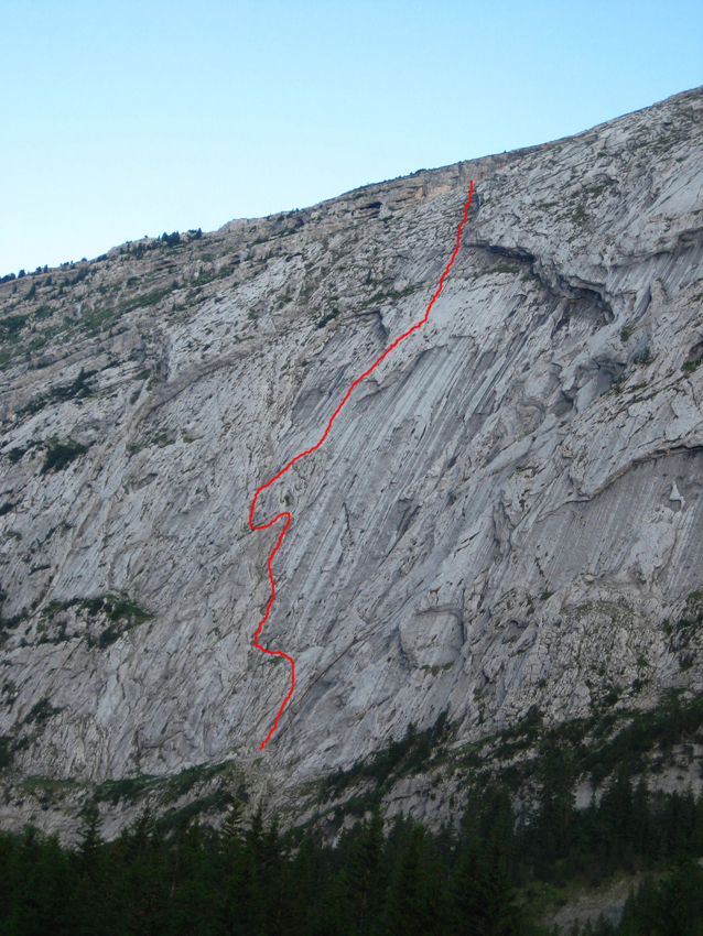

Details
Approach # Approximately 1h from the parking.
From the Lac Bénit, take a small path on the left side which rises into the forest. The path is marked in red signs on the trees. Follow the path, direction Des Dalles. From here, two solutions : • Solution 1 (easy) : Keep on this path until it comes out of the trees. After another 20 metres height gain, the start of the route is visible. Continue past the line of the route then come back sharply climbing to the start by grassy steps, on a faint but discernable path. • Solution 2 (more difficult but more direct). A second track to the right leads directly to the rockface. A short scramble leads to the beginning of the route.
Route # Approximately 400m of climbing
L# | 4c | A slab just to the right of the obvious chimney. (The first protection point is at 8 metres). Belay on a ledge. L# | | Follow the ledge on the left to a second chimney/crack. L# | 4c | Climb the chimney. Belay at the top on a ledge. L# | 4c | Climb the crack above. Belay on the ledge. (Up to here, new bolts, because the route is shared by « Hauteclaire » which splits off above). L# | 4b | Follow the ledge for about 10 metres, climb the steps (delicate, poor rock) and then a slab. Belay in a small hollow at the foot of two corners. L# | 4c | Climb a ramp above the belay and then the obvious corner. L# | 5a | Continue up the corner. Belay at the top (on the right) just as the corner curves a little towards the left. Pitches 6 and 7 give excellent climbing! L# | 5b | Either go straight up (less interesting rock) or traverse about 10m to the right and climb a slab, slightly diagonally to the left. 2 bolts in the slab. L# | 4a | Slab, first obliquely left, then straight up. L# | 4b | A rather grassy slab. Start by traversing right then come back left under the overhanging rockband to the belay. L# | 4a | Slab obliquely to the left staying below the overhang. No pre-bolted belay. L# | 3c | Continue easily to the end of the difficulties. Again, no pre-bolted belay.
Descent # 1h45 approximately back to the parking
Gain the summit crest of Petit Bargy. From the summit take the marked footpath from the Col de l’Encrenaz which descends to the lake. The path is sometimes steep and exposed.
The descent by the Encrenaz gully is also possible, with care. From the top of the route, traverse upwards towards the summit crest on rock and grass, then just grass. Do not traverse horizontally because of rock bands.

The text and images in this page are available
under a Creative Commons CC-by-sa licence.

Download the Whympr App to view this route in 3D.
- Route search (100 000)
- Community returns
- Weather forecast
- Avalanche bulletin
- Race book
- Creation of tracks
- Topographic map (including IGN)