

Open this outing in the app to prepare your next outing.

Grand Glaiza
Italy • 3293 m

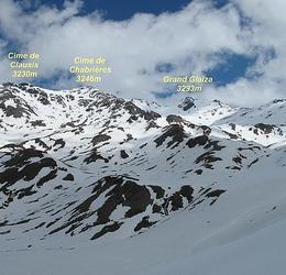
Panorama
Vue">https://tour.klapty.com/2Ma0mhRYoV/?deeplinking=true&startscene=6&startactions=lookat(-227.61,7.75,30.3,0,0);">Vue du Sommet Bucher par Eric Lafargue Vue">https://www.toporandosmontagne.com/05/queyras/bric-froid/pano-bric-froid-annote.JPG">Vue du Bric Froid par toporandosmontagne.com Vue">https://www.toporandosmontagne.com/05/queyras/malrif-glaiza/pano-g-glaiza-annote.JPG">Vue du Grand Glaiza par toporandosmontagne.com Vue">https://www.toporandosmontagne.com/05/queyras/malrif-glaiza/pano-pic-malrif-vierge.JPG">Vue du Pic de Malrif par toporandosmontagne.com Vue">https://www.mountainpanoramas.com/___p/___p.html?panoid=2015_BO&labels=on">Vue du Bric Froid par Dirk Becker (SW-W) Vue">https://www.mountainpanoramas.com/___p/___p.html?panoid=2015_Q3&labels=on">Vue de la Gardiole de l’Alp par Dirk Becker (N)
Historique
- 1re ascension : 1835 - Capitaine Cossato de l’État-Major Sarde.
- Arête NW : 1re ascension connue : 10 septembre 1877 - Grille, Laurens, Scherbeck.
- Arête SSW : 1re ascension connue : 19 août 1884 - Christian Almer fils, W. A. B. Coolidge.
- Couloir NE de la brèche Bertine-Glaiza et arête SE : 1re ascension : 16 juillet 1897 - Antonio Chiavero, Ernesto Sandri. Aller-retour.
Bibliographie
- Dal Monviso al Monte Rosa : statistica delle prime ascensioni par Luigi Vaccarone, [Bolletino CAI, vol. 19, 1885, no52, p.166-167](http://www.tecadigitale.cai.it/periodici/PDF/Bollettino/Bollettino del Club Alpino Italiano_1885_52.pdf#page=187) : mention de la 1re ascension (en italien).
- Annuaire">https://books.google.fr/books?id=wlt1o26R_lsC&pg=PA88&hl=fr&source=gbs_toc_r&cad=3#v=onepage&q&f=false">Annuaire STD 1877, p.88 : mention de l’ascension de 1877.
- Grand Glayza par W. A. B. Coolidge, Alpine">https://books.google.bj/books?id=WRYmEEEnUGkC&pg=PA112&hl=fr&source=gbs_toc_r&cad=3#v=onepage&q&f=false">Alpine Journal, vol. 12, no86, 1884, p.112 : chronique de l’ascension de 1884 (en anglais).
- Le Pic du Grand Glayza par G.-C. Paris - Revue des Alpes Dauphinoises, 1898, no3,">https://archive.org/details/revuedesalpesda00unkngoog/page/n72">no3, p.57-60 et no4,">https://archive.org/details/revuedesalpesda00unkngoog/page/n96">no4, p.81-84.
- Punta Merciantaira, Gran Glayza o Cima Clausi par A. Chiavero, Rivista">https://tecadigitale.cai.it/periodici/PDF/Rivista%20mensile/CAI_Rivista%20mensile%20del%20CAI_017_009_1898.pdf#page=6">Rivista Mensile CAI, vol. 17, 1898, no9, p. 324-326 : récit de l’ascension du couloir NE de la brèche Bertine-Glaiza (en italien).

Routes

Download the Whympr App to view this POI in 3D.
- Route search (100 000)
- Community returns
- Weather forecast
- Avalanche bulletin
- Race book
- Creation of tracks
- Topographic map (including IGN)