

Open this route in the app to prepare your next outing.

Details
Approach
From the Charpoua hut, go up to a large horizontal ledge at the foot of the S pillar.
Route
Slabs at 4b diagonally to the left until a terrace at the foot of the first step, a cliff of 80m. A chimney with two parallel cracks, (5b/c), exposed. Then a succession of cracks and corners at 4c to 5c until a narrow gully which descends to the left towards the Dru Couloir. Cross the couloir and follow a series of cracks and corners, (4b and 5b) until the foot of the Trident. By a ledge to the right, climb a chimney, (5b) to a « window », (gap) which marks the end of the second step. A series of short walls(50m at 4b) leads to a damp chimney, cross it (4b) at the level of an avoidable jammed boulder. Then again a series of chimney corners and cracks (together between 4b and 5b) until a large terrace at the foot of the final step.
Go towards the “Pilier Rouge”, (red pillar) crack on the right, pass under an overhang and go around a large boulder. Get to the rib of the Pilier Rouge ridge. Corner of 30m (4c), small overhang, and runnels the length of a vertical wall (5c, exposed.) Some small corners at 4b lead to the final ridge, then without difficulty to the summit by steps/ledges.
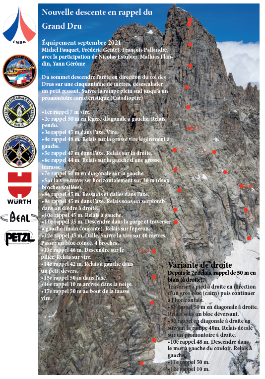
Descent # (from the Grand Dru )
Follow some ramps on the Charpoua, (E) side, exposed, to come back progressively to the left in about 100m of down climbing. Reach the rings, (bolt) of the first abseil, under a little pinnacle with a boulder on top. The abseils lead down to the glacier, the abseil points always being to the left, (looking outwards.) Careful, however, with the last abseil, a full 50m, which puts you onto the glacier. There is a real risk of getting the ropes jammed. Perhaps take an intermediatary abseil. From the top of the glacier, there is one more abseil to pass the bergschrund, (difficult to see the slings under the snow and rocks.)
Descend the glacier on its true right side until you reach your approach tracks which went towards the starting ledge.

The text and images in this page are available
under a Creative Commons CC-by-sa licence.

Download the Whympr App to view this route in 3D.
- Route search (100 000)
- Community returns
- Weather forecast
- Avalanche bulletin
- Race book
- Creation of tracks
- Topographic map (including IGN)