

Open this route in the app to prepare your next outing.

Details
Approach
From the parking at Bonnenuit it is about 1 1/2hrs to the Refuge Aiguille d’Arves. From here take the path into the Coombe des Aiguilles d’Arves and then aim across boulders and broken rock to the Col de Petit Jean (@2hr 15min). From here the route starts where a vague trail meets the face. First bolt visible from the ground.
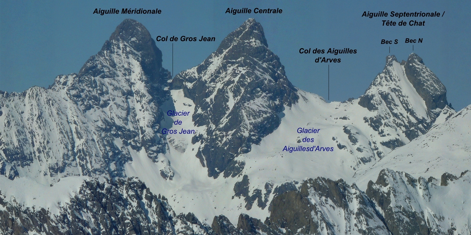
Aiguille Septentrionale d’Arves # (ou Tete du chat)
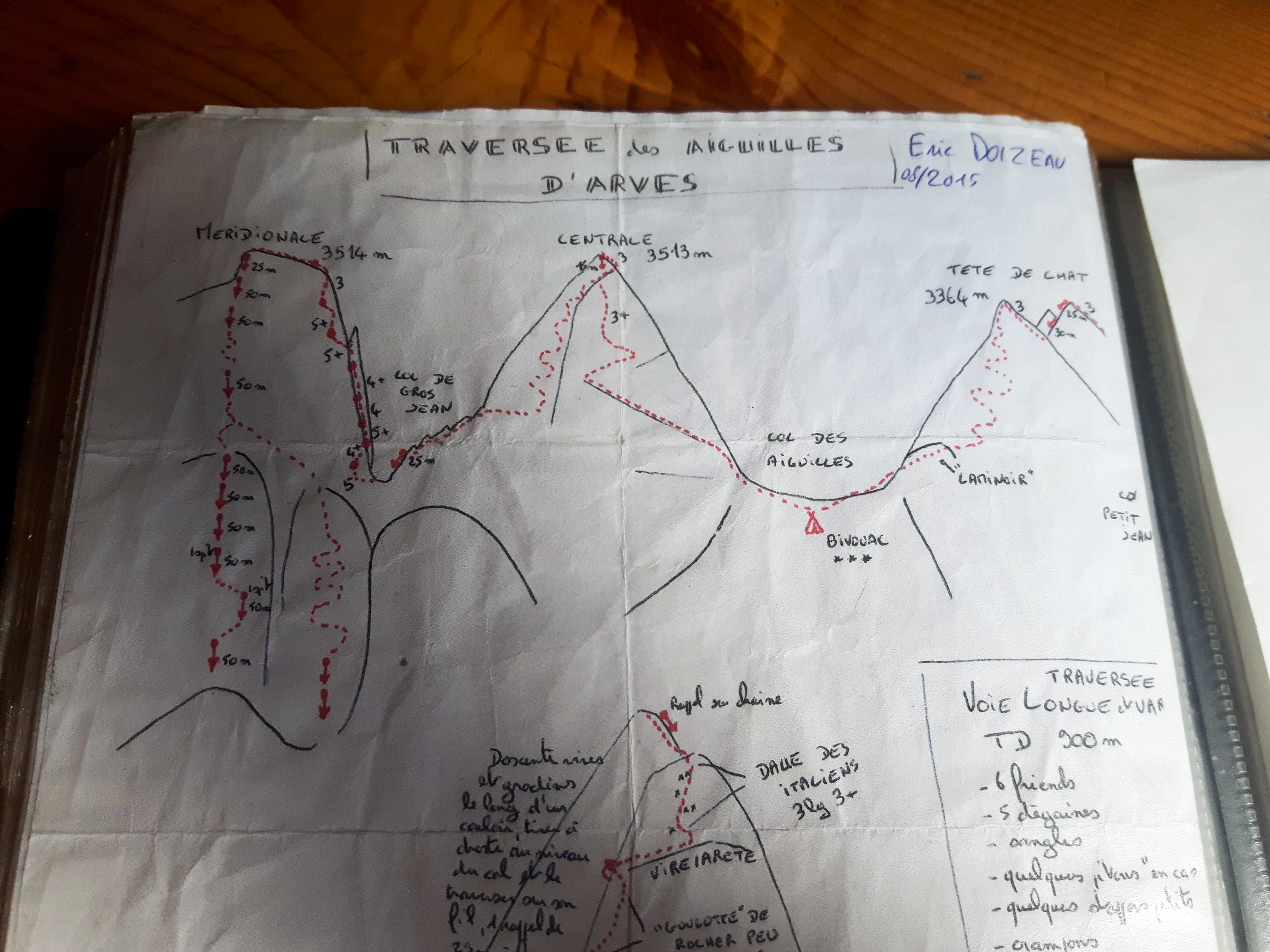
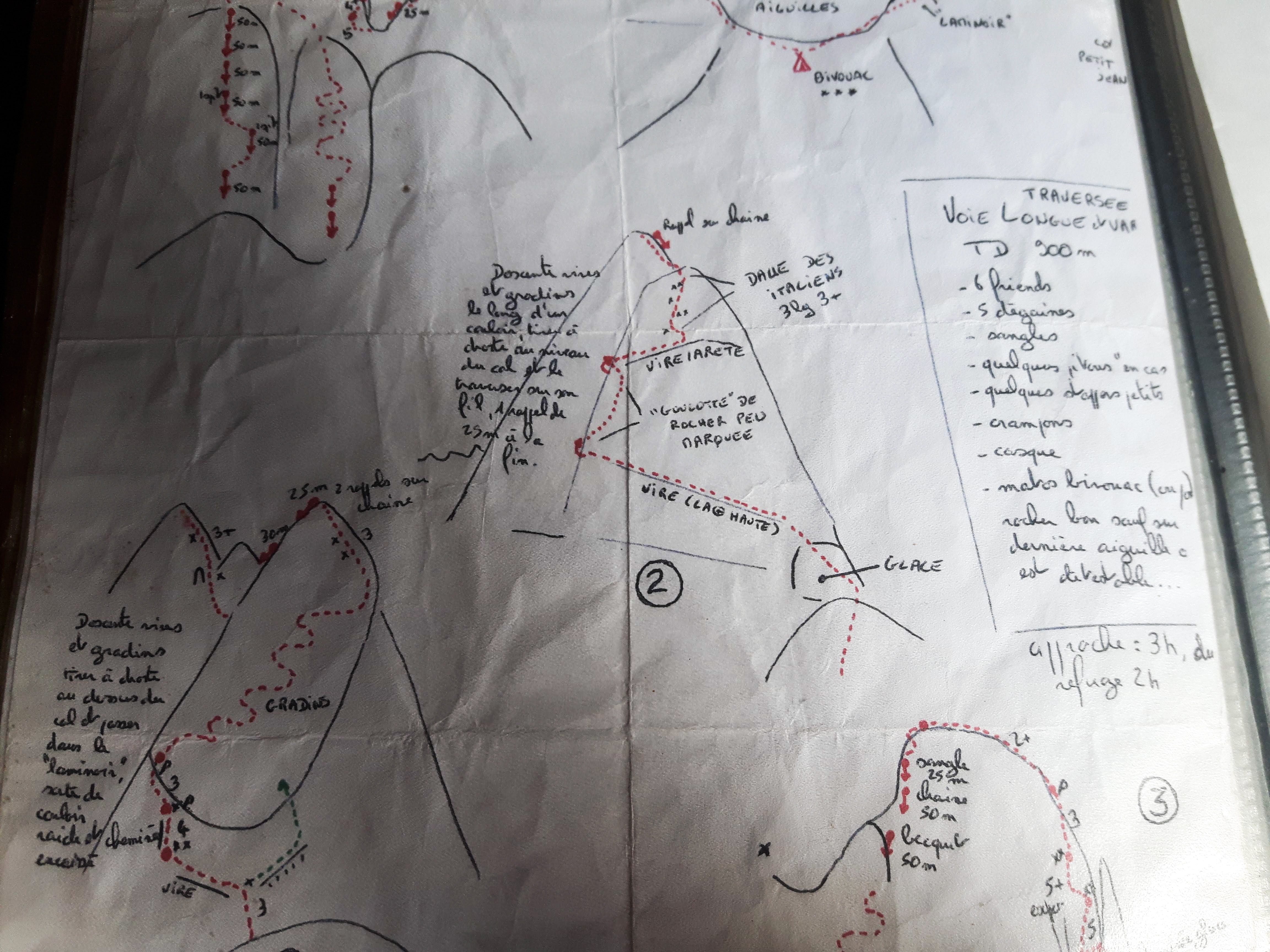
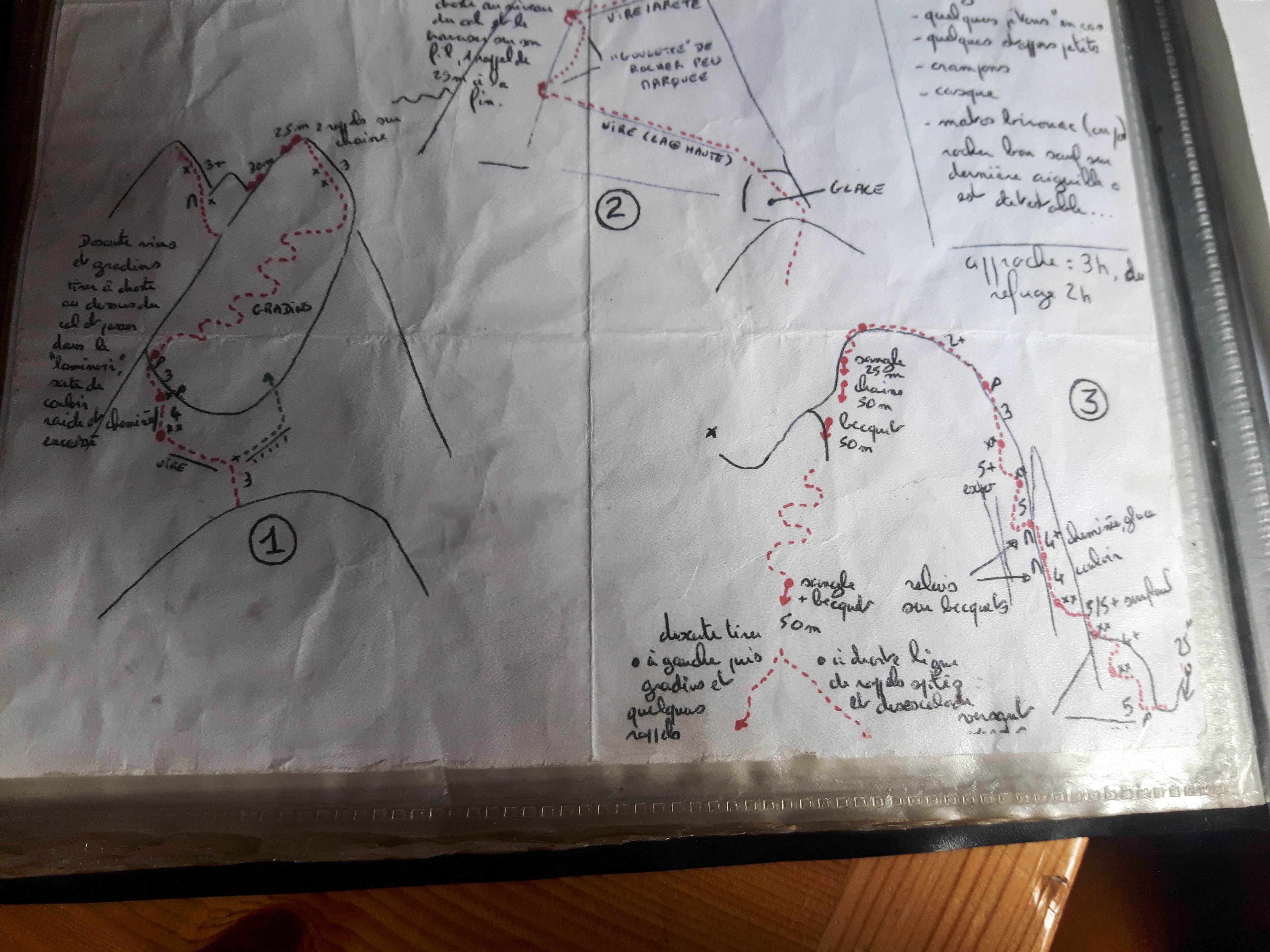
Start by climbing obliquely up and left towards the first bolt visible from the ground. A second bolt about 10m higher marks the start of a traverse across a slaby ledge, first down then up along a break in slabs, more bolts, aiming at the foot of a little chimney. Climb the chimney (IV+) bolt visible at last moment, then continue up the fault line, pitons, ascending slightly left. The angle eases. Climb following easy fault lines, slight right then slightly left (follow easiest line) 3/4 to the summit of the Septentrionale. Look for a first chain rappel point at the edge of the arete which leads towards the south summit. 1st abseil: 25m to chain anchor, left of arete looking down. 2nd abseil: 30m to easy ground or 25m and a little downclimbing to reach easy ground. Looking down you see a breche and slab with violet/white cordalette leading over the slab- aim for this, left of arete looking down. From the couloir climb to the breche (easy but delicate rock) then climb leftwards more easily lines of weakness to the south summit (Bec S) about 3hrs.
To descend downclimb the east face following cairns (easy terrain) some bolts/maillon for abseiling the more delicate sections. Either to the centrale couloir (marked by a big cairn 2×50 m rappels to easy ground), but we didn’t identify this easily, or to the normal route ascent couloir which is much more obvious and easier.
Aiguille Centrale
Start the climb along the higher of two obvious ledge systems which cut the face. This traverses easily up and left with evidence of other people’s passage and cairns until a distinct change in aspect of the face. (The same ledge now continues on the other face in descent- but you leave it here. Follow and easy arete which leads to another easy ledge up and rightwards until a large cairn and the ledge begins to descend. Leave this ledge and climb up and leftwards onto another ledge/faultline which heads up and left following cairns. The ledge gets narrower and is protected by a couple of bolts before a breche with cairns and white arrows leading back the way you’ve just come. At the arrows cut up right across easy ground to the summit.
To descent to the Col de Gros Jean (3265m) from the summit of the Aiguilles Central, first descend to the end of the ledge system where the cairn marked** was and the white arrows. Now first follow the ledge/fault line down in the direct of Col Gros Jean, then soon leave it and follow easy fault lines down and across right into the couloir which leads from the summit towards the Glacier below. Once in the rock couloir continue easily down to another ledge system which is followed (sometimes delicate sections and exposed) to just above the red pinacles before the Col Gros Jean. Traverse or by pass the pinnacles until you reach a rappel at the end from bolts and tape/slings. Short rappel into the col with bivouac places but no water.
Aiguilles Méridionale
From the Col Gros Jean the main line of the route is a big charecteristic corner on the right side of the face. 3/5hrs for the climb. Start by climbing out right onto the west face, slight down and out of sight of the belayer. Pitons almost immediately. L#1 | 45m | IV+ | Climb out of the bivouac along a sloping ledge, out of sight up and right (Piton) then up a steep wall then ascending rightwards along a fault to belay on two bolts below a chimney/crack system. L#2 | 30m | IV+ | Climb the crack system up, then branch left and straight up to the ridge. Belay on two bolts at the top. L#3 | 30m | V+ | Climb the maroon wall to the left of the yellow slap, up and leftwards following the line of weakness. Pitons x2, and not so good rock. Belay on bolts at the top, below a corner system. L#4 | 40m | IV | Climb the corner system, mindful of the lose blocks until you can climb the right wall on more solid rock up onto slabs and back into the corner/chimney feature. Belay on a peg and a spike just before the chimney widens and deepens. L#5 | 40m | V | Climb the chimney past a large chockstone, DO NOT continue up this feature which runs to a pinnacle summit on the R of the face, instead traverse left into the left hand branch and continue up easier ground to make a belay where possible. L#6 | 20m | IV+ | Climb the easier slabs to just below and overhang and belay on 2 bolts. L#7 | 30m | V+/IV | Climb up and left of the belay ascending leftwards … friend trapped at mid-height. Belay on bolts. L#8 | 25m | III+ | Climb up and right to regain the ridge. Belay on one bolt on the ridge. L#9etc | 150m | III | Continue up the ridge to the summit.
Descent
From the summit : Continue along the south ridge easily on the crest until you find an abseil point on a Spike (Slings, rope, Maillon) R#1 | 25m | To a chain belay left of ridge looking down.
R#2 | 25m | To an obvious breche which has a piton and bolt abseil anchor. R#3 | 25m | Follow the left edge of the arete which forms the border of the couloir from the breche. R#4 | 25m | To a big obvious ledge.
The 5th rappel is found slightly below the ledge behind the big cairn, chain anchor.
R#5 | 50m | Make a long rappel to a slabby section of rock with no anchor obvious. Pull the ropes and then move about 25m rightwards (Looking down) to find another rappel anchor which is not obvious but has white chord and bolts.
R#6 | 50m | Slightly right (Looking down)to another chain.
R#7 | 50m | To easy gound and downclimb to obvious ledge or 60m to obvious ledge. slight right (Looking down). Now continue along this obvious ledge which cuts the whole face. Easy but exposed. Bolts every 25m. To a prominent breche (Breche Brull). downclimb into the breche, around the pinnacle and up the other side 2xbolts to a chain belay. III+. follow the fault line on the left side of the main arete, with bolts every 25m. If you lose the bolts just stay on the left flank staying relatively high on the ridge and even rejoining it after a while until it is possible to enter the big stoney slopes below the point Salvador. Do not descent too much before this point. Then go down and traverse rightwards (looking down) to find the best way down the steep and at times expose scree slopes. 3/4hrs to the hut.

The text and images in this page are available
under a Creative Commons CC-by-sa licence.

Download the Whympr App to view this route in 3D.
- Route search (100 000)
- Community returns
- Weather forecast
- Avalanche bulletin
- Race book
- Creation of tracks
- Topographic map (including IGN)