

Open this route in the app to prepare your next outing.

Details
Approach # to the Monzino hut 2-3h
Start from Freney - Chalet du Miage, in the Val Veni (1590m), large parking near the river. Follow the well signposted path across the river, (bridges.) N.B. the IGN map shows that it is possible to start higher up. There are no longer bridges in place and can be difficult to cross the river.
Follow the path to the hut by a steep path which climbs 2 rock bands, and has cables etc.
Route
1st part of the ridge # (The intégrale)
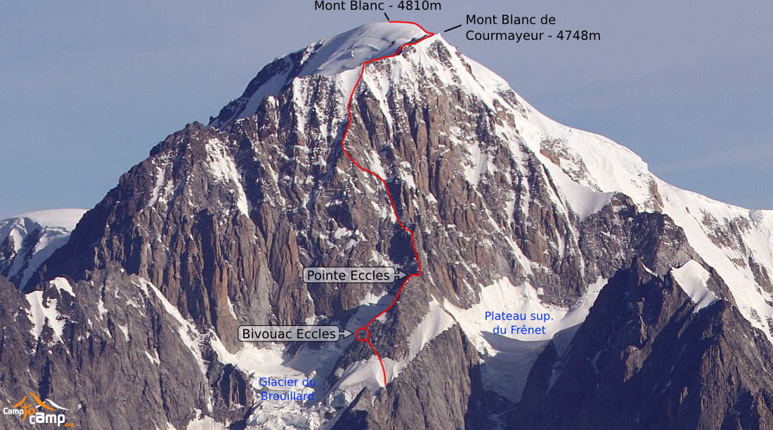
From the hut go up the scree to the shrinking Châtelet glacier which you climb for 100m to a low, rock band (1h.) Overcome this band and continue up steps, identifying a notable pinnacle on the SW ridge, which you reach by a corner crack (4b) and go around on the Châtelet side. Take the best line up the W face on suspect rock to the ridge, (4b, 2h30.) Climb the ridge to the summit of the l’Innominata (3750m, 1h30). Make three abseils to the Col de Frêney. Traverse the narrow crest then descend 30m onto the glacier plateau which you cross. Overcome the bergschrund and reach, by steep slopes, the Eccles bivouac (3850m, 2h).
To go directly to the Eccles Bivouac # (direct variant)
From the hut go up the scree to the shrinking Châtelet glacier. Go off to the left to reach the Brouillard glacier. Go up this to the col de Freney (careful numerous and impressive crevasses.) From the col climb up towards the Pointe Eccles by a steep and sustained, snow slope, (often ice) until a level area. Go obliquely to the left on mixed ground to reach the bivouac.
2nd part of the ridge
From the Eccles bivouacs to the Col Eccles (2 solutions.) 1) In good snow conditions, find the abseil point to go down a slope 50m behind the old bivouac, (bergschrund) to get to the Brouillard glacier, which you climb up to the Col Eccles (45°). (1h30, more if conditions are bad!) 2) Or climb the SW ridge towards the Pointe Eccles (from the bivouac go up towards a large, wooden stick on the ridge.) Climb the ridge until a little step under the Point. You can go around the step to the left (Brouillard side, short abseil) or climb a crack on the right (Freney side). Both lead to Pointe Eccles (4050m, 4b), then an abseil down to the snow ridge of the Col Eccles. (2h.)
Keep to the crest of the ridge until the first steep step, which you overcome by 3-4 sustained pitches, (an obvious 20m corner with a move of 5b to exit.) Go under a large boulder then follow the crest of the spur, (4b, 3b, 2h). You reach a little snow ridge (sometimes just a blade of snow) below an immense and smooth pinnacle of, in places, loose rock. Go around the pinnacle to the left and climb a steep step in two short pitches, (3b-4b, loose) towards the large couloir of snow/ice between the Innominata and a secondary ridge to the left. Cross it (quickly, stonefall danger) to the left at 4250m and reach a rock incline, (1h30). Climb this incline, (large boulders,) and go obliquely to the left until a narrow snow/ice gully/ramp, (at the foot of an overhanging red tower) which starts to the left and leads to the Pointe Louis Amédée ridge. Climb this ridge to its top, (4450m, 3b-4b, 2h30). From here, climb the ice/mixed slopes to the Pointe (4650m, 50°). Finally, follow the rocky ridge, then snowy and again rocky, (climb a large rocky step on the right.) One can “tick” the Mont Blanc de Courmayeur by an obvious contour above the SW face (35°, ice or snow, careful of windslab) and at last the summit of Mont Blanc (2h).
Descent
- Either the Bosses-Gouter ridge to Les Houches,
- Or the 3 Monts to the Aig du Midi
- Or the normal route on the Italian side , the Aiguilles Grises, Gonella hut. (The glacier can be very difficult, especially at the end of the season.) Then back to the parking!

The text and images in this page are available
under a Creative Commons CC-by-sa licence.

Download the Whympr App to view this route in 3D.
- Route search (100 000)
- Community returns
- Weather forecast
- Avalanche bulletin
- Race book
- Creation of tracks
- Topographic map (including IGN)